|
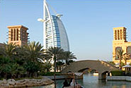
The Geographic Information Systems, GIS, Department at the Dubai Municipality today said it completed 3D photography of all the landmarks and buildings in the emirate in record time and transferred them to its main database through its smart systems as part of its project to provide accurate and high-quality GIS data.
Dawoud Al Hajri, Director-General of Dubai Municipality, said the project is part of the implementation of Dubai’s smart transformation plan under the directives of H.H. Sheikh Hamdan bin Mohammed bin Rashid Al Maktoum, Crown Prince of Dubai and Chairman of Dubai Executive Council.
The 3D photography process, completed in April, was conducted using the Dubai Municipality's Geospatial Scanning Vehicle, an integrated solution for collecting geospatial data. The solution, which features equipment mounted on a car’s roof was used to conduct a field survey and capture high-quality 3D data on landmarks of the emirate.
Equipment used for the survey included a high-resolution laser scanner, satellite positioning devices and a set of 360-degree panoramic cameras. The data, captured while the car travels at a speed of 80 km per hour, is processed to produce an integrated digital model.
The geospatial survey system enables high levels of accuracy, speed and safety in data collection operations in all areas, including congested areas. The solution efficiently produces 3D models and captures accurate data on all kinds of landmarks, including diverse government assets, whether they are open cultivated areas, parks, squares, playgrounds, underground tunnels, infrastructure installations, event sites and vast interiors of buildings such as airports, exhibitions and more.
The system's output outperforms other systems used for the panoramic imaging of landmarks, with its laser devices that produce dense clouds of coordinates (Point Cloud), which shape the landmarks geometrically with a precision of 5 cm. This enables the production of 3D models of all the landmarks covered and its conversion into accurate data. Compared to this, parallel panoramic photography only provides a general view.
The system’s features also include the extraction of data on landmarks and assets using Geospatial Artificial Intelligence that can be used at any time and any place as needed.
The Dubai Municipality is the first government department in Dubai to deploy such a system, which is a critical element of the Dubai Digital Twin Model for infrastructure enhancement.
|